|
Copies of the 1841 Tithe Map are now available for viewing in the
Gargrave Library. These maps languished in Craven District Councils
storeroom for decades gathering dust until they were rescued and sent
off to Northallerton last year for safe keeping. They have been
microfilmed and copied into a series of smaller sections of the original
and make compulsive viewing. To compliment the maps the there is a copy
of the Tithe Register necessary to sort out who owned what and when.
Bernadette, our Librarian, will be pleased to advise potential viewers.
|
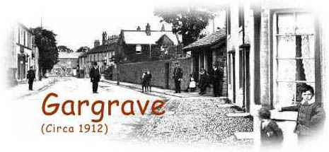
 For
a small place Gargrave has a fair amount of documented history. Much
of the pictorial record around the start of the twentieth century
came from
For
a small place Gargrave has a fair amount of documented history. Much
of the pictorial record around the start of the twentieth century
came from